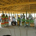
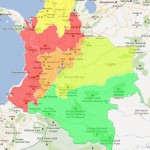
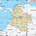
This is the most populated region in the country which is characterised by its diverse topography given by the Andes.
Near the Ecuadorian frontier, the Andes Mountains divide into three distinct, roughly parallel chains, called cordilleras, that extend northeastward almost to the Caribbean Sea. Altitudes reach more than 18,700 ft (5,700 m), and mountain peaks are permanently covered with snow. The elevated basins and plateaus of these ranges have a moderate climate that provides pleasant living conditions and in many places enables farmers to harvest twice a year. Torrential rivers on the slopes of the mountains produce a large hydroelectric power potential and add their volume to the navigable rivers in the valleys. In the late 1980s, approximately 78 percent of the country’s population lived in the Andean highlands.

Tatacoa Desert – Tourism in Colombia
The Cordillera Occidental in the west, the Cordillera Central in the center, and the Cordillera Oriental in the east have different characteristics. Geologically, the Cordillera Occidental and the Cordillera Central form the western and eastern sides of a massive crystalline arch that extends from the Caribbean lowlands to the southern border of Ecuador. The Cordillera Oriental, however, is composed of folded stratified rocks overlying a crystalline core.
The Cordillera Occidental is relatively low and is the least populated of the three cordilleras. Summits are only about 9,840 ft (2,999 m) above sea level and do not have permanent snows. Few passes exist, although one that is about 4,985 ft (1,519 m) above sea level provides the major city of Cali with an outlet to the Pacific Ocean. The relatively low elevation of the cordillera permits dense vegetation, which on the western slopes is truly tropical.
The Cordillera Occidental is separated from the Cordillera Central by the deep rift of the Cauca Valley. The Río Cauca rises within 124 mi (200 km) of the border with Ecuador and flows through some of the best farmland in the country. After the two cordilleras converge, the Cauca Valley becomes a deep gorge all the way to the Caribbean lowlands.
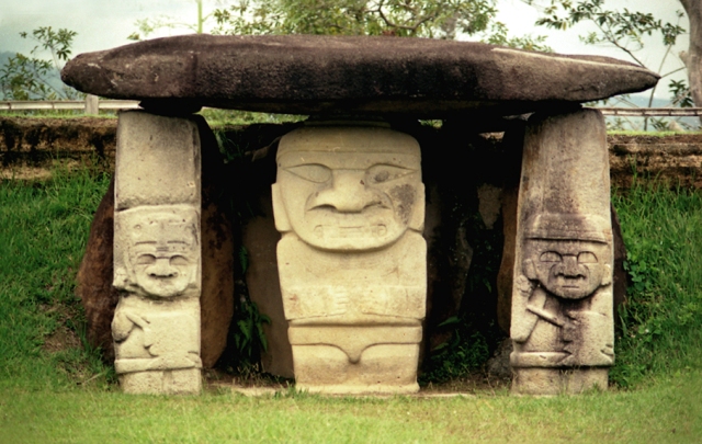
San Agustín – South America / Colombia
The Cordillera Central is the loftiest of the mountain systems. Its crystalline rocks form a towering wall dotted with snow-covered volcanoes that is 500 mi (805 km) long. There are no plateaus in this range and no passes under 10,825 ft (3,299 m). The highest peak in this range, the Nevado del Huila, reaches 17,602 ft (5,365 m) above sea level. The second highest peak is a volcano, Nevado del Ruiz, which erupted violently on November 13, 1985. Toward its northern end, this cordillera separates into several branches that descend toward the Caribbean coast.
In the Cordillera Oriental at elevations between 2,500 and 2,700 meters (8,202 and 8,858 ft), three large fertile basins and a number of small ones provide suitable areas for settlement and intensive economic production. In the basin of Cundinamarca, where the Spanish found the Chibcha Indians, the European invaders established the town of Santa Fe de Bogotá (present-day Bogotá) at an elevation of 2,650 meters (8,694 ft) above sea level.
To the north of Bogotá, in the densely populated basins of Chiquinquirá and Boyacá, are fertile fields, rich mines, and large industrial establishments that produce much of the national wealth. Still farther north, where the Cordillera Oriental makes an abrupt turn to the northwest near the border with Venezuela, the highest point of this range, the Sierra Nevada de Cocuy, rises to 5,493 meters (18,022 ft) above sea level. In the department of Santander, the valleys on the western slopes are more spacious, and agriculture is intensive in the area around Bucaramanga. The northernmost region of the range around Cúcuta is so rugged that historically it has been easier to maintain communications and transportation with Venezuela than with the adjacent parts of Colombia.<7p>
Tours & Tickets in Colombia
| COLOMBIA TRAVEL GUIDE |
| Related Articles |
If you’re travelling to Colombia, we help you:

![]() General Information About Colombia: National symbols of Colombia – Colombia: living history – Geography of Colombia – Economy of Colombia – Languages of Colombia
General Information About Colombia: National symbols of Colombia – Colombia: living history – Geography of Colombia – Economy of Colombia – Languages of Colombia
![]() Practical information about Colombia: Climate – How to get to Colombia – Visa, Customs, Documentation and Taxes – Embassies and consulates in Colombia – Health and vaccination – Emergency numbers – Culture of Colombia – Measures and Electricity – Currency of Colombia
Practical information about Colombia: Climate – How to get to Colombia – Visa, Customs, Documentation and Taxes – Embassies and consulates in Colombia – Health and vaccination – Emergency numbers – Culture of Colombia – Measures and Electricity – Currency of Colombia
![]() Tourist Information about Colombia: General Information – Practical information about Colombia – Adventure Colombia – Hotels and accommodations in Colombia – How to Get to Colombia – Gastronomy in Colombia – Colombia’s Best Festivals and Carnivals – Tourist Attractions in Colombia – Foreign Embassies and Consulates in Colombia – Tips and advice for travel in Colombia – Top 10 Colombian Travel Destinations – Natural regions of Colombia – Cultural Tourism in Colombia – UNESCO Intangible Cultural Heritage Lists – UNESCO Heritage Sites in Colombia – Top 10 amazing places to visit in Colombia – Colombian Cuisine – Tourism of Nature
Tourist Information about Colombia: General Information – Practical information about Colombia – Adventure Colombia – Hotels and accommodations in Colombia – How to Get to Colombia – Gastronomy in Colombia – Colombia’s Best Festivals and Carnivals – Tourist Attractions in Colombia – Foreign Embassies and Consulates in Colombia – Tips and advice for travel in Colombia – Top 10 Colombian Travel Destinations – Natural regions of Colombia – Cultural Tourism in Colombia – UNESCO Intangible Cultural Heritage Lists – UNESCO Heritage Sites in Colombia – Top 10 amazing places to visit in Colombia – Colombian Cuisine – Tourism of Nature
![]() Travel Guide of Colombia: Colombia Travel Guide – Amazonas – Antioquia – Arauca – Atlántico – Bolivar – Boyacá – Caldas – Caquetá – Casanare – Cauca – Cesar – Chocó – Córdoba – Cundinamarca – Guanía – Guaviare – Huila – La Guajira – Magdalena – Meta – Nariño – Norte de Santander – Putumayo – Quindio – Risaralda – San Andrés y Providencia – Santander – Sucre – Tolima – Valle del Cauca – Vaupés – Vichada
Travel Guide of Colombia: Colombia Travel Guide – Amazonas – Antioquia – Arauca – Atlántico – Bolivar – Boyacá – Caldas – Caquetá – Casanare – Cauca – Cesar – Chocó – Córdoba – Cundinamarca – Guanía – Guaviare – Huila – La Guajira – Magdalena – Meta – Nariño – Norte de Santander – Putumayo – Quindio – Risaralda – San Andrés y Providencia – Santander – Sucre – Tolima – Valle del Cauca – Vaupés – Vichada
Share:

Flights, Cheap Airfare Deals & Plane Tickets |